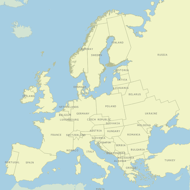
The western United States' borders are not drawn based on the traditional metes and bounds system of delineating borders. Instead, the borders are drawn based on the Public Land Survey System which people commonly refer to as range and township. The map above shows what Europe would look like if the continent's borders were drawn based on range and township instead of metes and bounds.
Findings
- Norway, Sweden, and Finland resemble Canadian provinces.
- The borders of Europe would not look all that different than they do today.
Caveats
- There was no science behind how the borders were drawn. They were drawn along the nearest meridian, parallel, or a diagonal line was drawn where the first two options would severely alter the boundaries of a state.
Details
The Public Land Survey System was created to mete out land sight unseen. This made the traditional way of delineating land quite difficult as no one knew what the natural landmarks were in the area. So Thomas Jefferson devised a system that relied on meridians and parallels to identify boundaries.
This created a new problem however, because meridians, unlike parallels are not, well, parallel. The closer they get to the poles, the closer they get to each other and thus cannot be perfect squares. The closer one gets to the poles, the narrower that particular plot of land becomes.
On the flip side, the range and township method is superior to the metes and bounds method in that one does not need to worry about the course of a river changing, erosion, and various other geographic events that would alter the boundary under the metes and bounds system. Boundaries are delineated based on a theoretical plane and no geographic event can alter that.
Sources
Wikipedia. 2017. "Public Land Survey System." Accessed October 27, 2017. https://en.wikipedia.org/wiki/Public_Land_Survey_System.