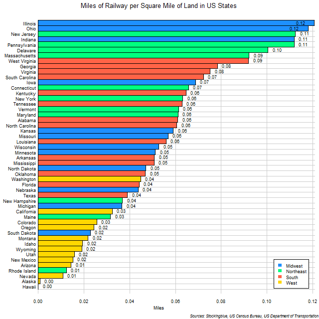
The chart above shows the miles of rail per square mile of land in US states. It's surprising to see that Western states have so little rail compared to the size of their area as rail has been romantically associated with the frontier lands.
Findings
- The difference between the state with the greatest rail coverage, Illinois, and the state with the least, Alaska (Hawaii has no rail network), is 0.12 miles.
- Illinois has 159 times the rail coverage that Alaska has.
- Only six states (Illinois, Ohio, New Jersey, Indiana, Pennsylvania, and Delaware) have a tenth of a mile of rail or more for every square mile of territory.
- The mean miles of rail per square mile of land of the 50 states is 0.05 and the median is also 0.05.
Caveats
- Rail length data is from 2013.
- Area data is from 2010.
- Road and area data come from different sources.
- Numbers in the chart are rounded to the nearest hundredth.
- Hawaii has no rail network.
Details
Every single Western state has less than 0.05 miles of rail for every square mile of territory with Washington, the Western state with the greatest rail coverage, ranked 30th out of 50 states. Only two Southern states rank below the highest ranked Western state, and only three of each from the Midwest and the Northeast are bested by Washington.
The number of miles of railway per square mile of land for the United States as a whole is 0.04 which ranks it just below Michigan and just above California (the numbers in the chart are rounded to the nearest hundredth).
Sources
United States Census Bureau. "Annual Estimates of the Resident Population: April 1, 2010 to July 1, 2016." Accessed December 12, 2017. http://factfinder2.census.gov.
United States Department of Transportation. 2015. "State Transportation by the Numbers." Accessed March 21, 2018. https://www.bts.gov/sites/bts.dot.gov/files/legacy/_entire.pdf.