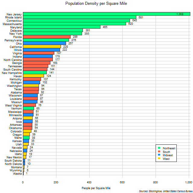
The chart above shows the population density of US states. Surprisingly, it is not a small state that is the most densely populated, however it does adjoin two major metropolises in New York and Philadelphia.
Findings
- The difference between the most densely populated state, New Jersey, and the least, Alaska, is 1,007 people per square mile.
- New Jersey is 944 times more densely populated than Alaska.
- Every state is at least 75% as densely populated as the next more densely populated state except for Rhode Island (68% as densely populated as New Jersey), South Dakota (62% of New Mexico), Montana (71% of North Dakota), and Alaska (19% of Wyoming).
- Even though New Jersey is the most densely populated state, it only takes the sum of the next two states' densities (Rhode Island and Connecticut) to rival it.
Caveats
- Area data is from 2010.
- Population data is from 2010.
- The area includes both land and water area.
- Population and area data are from different sources.
- The Northeastern US consists of New York, Pennsylvania, New Jersey, Massachusetts, Maryland, Connecticut, New Hampshire, Delaware, Maine, Rhode Island, and Vermont.
- The Southern US consists of Texas, Florida, Georgia, North Carolina, Virginia, Tennessee, Louisiana, South Carolina, Alabama, Kentucky, Oklahoma, Arkansas, Mississippi, and West Virginia.
- The Midwestern US consists of Illinois, Ohio, Michigan, Indiana, Minnesota, Wisconsin, Missouri, Iowa, Kansas, Nebraska, North Dakota, and South Dakota.
- The Western US consists of California, Washington, Colorado, Arizona, Oregon, Utah, Nevada, New Mexico, Hawaii, Idaho, Alaska, Montana, and Wyoming.
Details
Eight of the ten most densely populated states are in the Northeastern US. The Western US has the least densely populated states.
The US's population density according to this data, is 81 persons per square mile meaning that 28 states have a greater population density (all except for two from the Northeast, all except for four from the South, half the Midwestern states, and three from the West) than that of the entire US whereas 22 states have a population density lower than that of the US as a whole.
Sources
United States Census Bureau. "Annual Estimates of the Resident Population: April 1, 2010 to July 1, 2016." Accessed December 12, 2017. http://factfinder2.census.gov.
United States Census Bureau. September 2012. "United States Summary: 2010: Population and Housing Unit Counts." Accessed January 23, 2018. https://www.census.gov/prod/cen2010/cph-2-1.pdf.