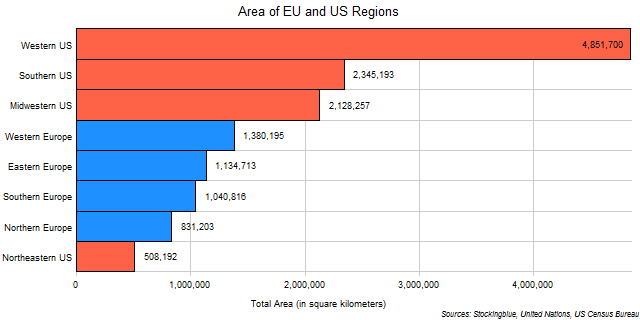
The chart above shows the area of each of the EU and US regions. The Western US is so large that it can fit the entirety of the European Union within it.
Findings
- The difference between the largest region, the Western US, and the smallest, the Northeastern US, is 1,677,037 square miles (4,343,506 square kilometers).
- The largest region, is 9.55 times larger than the smallest region.
- The difference between the largest and smallest regions amounts to 855% of the smallest region's area and 90% of the largest region's area.
- The Northeast is three-fifths the size of Northern EU which is four-fifths the size of Southern EU which is nine-tenths the size of Eastern EU which is four-fifths the size of Western EU which is the fifths the size of the Midwest which is nine-tenths the size of the South which is nearly half the size of the West.
Caveats
- EU data is from 2007 and US data is from 2010.
- The area includes both land and water area.
- The Western US consists of California, Washington, Colorado, Arizona, Oregon, Utah, Nevada, New Mexico, Hawaii, Idaho, Alaska, Montana, and Wyoming.
- The Southern US consists of Texas, Florida, Georgia, North Carolina, Virginia, Tennessee, Louisiana, South Carolina, Alabama, Kentucky, Oklahoma, Arkansas, Mississippi, and West Virginia.
- The Midwestern US consists of Illinois, Ohio, Michigan, Indiana, Minnesota, Wisconsin, Missouri, Iowa, Kansas, Nebraska, North Dakota, and South Dakota.
- Western Europe consists of Germany, United Kingdom, France, Netherlands, Belgium, Austria, Ireland, and Luxembourg.
- Eastern Europe consists of Poland, Czech Republic, Romania, Hungary, Slovakia, Bulgaria, Croatia, Slovenia, Lithuania, Latvia, and Estonia.
- Southern Europe consists of Italy, Spain, Portugal, Greece, Cyprus, and Malta.
- Northern Europe consists of Sweden, Denmark, and Finland.
- The Northeastern US consists of New York, Pennsylvania, New Jersey, Massachusetts, Maryland, Connecticut, New Hampshire, Delaware, Maine, Rhode Island, and Vermont.
Details
Considering how the EU's population is larger than the US's, one can see how crowded the European Union is compared to the United States.
The total area, according to this data, of the European Union is 4,386,927 square kilometers (1,693,802 square miles), and the total area of the United States is 9,833,342 square kilometers (3,796,675 square miles).
Sources
United Nations. 2007. "United Nations Statistics Division - Environment Statistics." Accessed January 23, 2018. https://unstats.un.org/unsd/environment/totalarea.htm.
United States Census Bureau. September 2012. "United States Summary: 2010: Population and Housing Unit Counts." Accessed January 23, 2018. https://www.census.gov/prod/cen2010/cph-2-1.pdf.